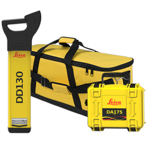

Leica 6014157 Depth Package Kit, DD130 60Hz Utility Locator, DA175 1 Signal Transmitter, Carry Bag
Our Part #10177831
Condition:New
Mfr Part #6014157
- Description
- Specifications
- Documents
Leica Geosystems 6014157 Detect Depth Package with DD130 Utility Locator and DA175 Signal Transmitter
The Leica Geosystems 6014157 Detect Depth Package combines the DD130 utility locator and DA175 1 Watt signal transmitter to help locate and trace buried utilities before excavation. Designed for utility locating, underground cable detection, and pipe locating applications, this package provides depth estimation, signal tracking, and multiple operating frequencies to support safe and efficient site work.
The 6014157 package is well suited for utility contractors, survey professionals, construction crews, and infrastructure maintenance teams that require reliable underground utility detection. When used together, the DD130 locator and DA175 transmitter help identify the position of buried cables and pipes while providing depth estimation for improved situational awareness during excavation activities.
The package also includes an extension cable, system carry bag, alkaline batteries, and user documentation.
Specifications & Capabilities:
DD130 Utility Locator
- Application: Underground cable and pipe locating
- Detection Modes: Auto, Power, Radio, and Transmitter
- Power Frequency: 60 Hz mains power and harmonics
- Radio Frequency Range: 15 kHz to 60 kHz
- Transmitter Frequencies: 8 kHz, 33 kHz, 512 Hz, and 640 Hz
- Depth Range (Line): 0.3 m to 3 m (1 ft to 10 ft)
- Depth Range (Sonde): 0.1 m to 9.99 m (up to 32.77 ft)
- Depth Accuracy: ±10% under undistorted signal conditions
- Signal Strength Indication (SSI): Numeric signal strength display
- Hazard Zone Feature: Alerts users to shallow buried services within 30 cm
- Display: Monochrome screen
- Battery Type: 6 x AA alkaline batteries
- Typical Operating Time: Up to 15 hours
- Protection Rating: IP54
- Operating Temperature: -20°C to +50°C
- Dimensions: 85 x 250 x 760 mm
- Weight: 2.7 kg including batteries
DA175 Signal Transmitter
- Maximum Output Power: Up to 1 Watt
- Operating Frequencies: 8 kHz and 33 kHz
- Connection and Induction Modes: Supported
- Display Indicators: Battery, frequency, connection mode, and power output
- Keypad: 4 membrane push buttons
- Battery Configuration: Supplied with alkaline batteries
- Typical Operating Time: Up to 15 hours
- Protection Rating: IP67
- Dimensions: 250 x 206 x 113 mm
- Weight: 2.38 kg
- Operating Temperature: -20°C to +50°C
- Approvals: CE and FCC compliant
The DD130 locator is designed to simplify utility detection by eliminating the need for manual sensitivity adjustment. This helps reduce the possibility of missing detectable services due to incorrect sensitivity settings. An integrated self-test function allows operators to quickly verify proper instrument performance before use.
The locator also incorporates Signal Strength Indication (SSI) technology, providing a numerical signal strength readout that assists with cable identification and signal tracing. The built-in Hazard Zone feature alerts users when shallow buried services are detected nearby, helping crews make informed decisions before breaking ground.
When paired with the DA175 transmitter, the Leica Geosystems 6014157 package supports active tracing of underground utilities through transmitted locating signals. Available frequencies allow operators to select the most appropriate signal for different site conditions, whether locating utilities over longer distances or performing standard cable and pipe tracing tasks.
The depth estimation capability enables users to estimate the depth of buried lines and sondes, making the 6014157 Detect Depth Package a valuable tool for utility locating, damage prevention programs, construction site preparation, and excavation safety workflows.
Included Components:
- DD130 Utility Locator
- DA175 1 Watt Signal Transmitter
- Extension Cable
- System Carry Bag
- Alkaline Batteries
- User Manuals
- Manufacturer Warranty Documentation
Applications:
- Underground utility locating
- Cable and pipe detection
- Excavation safety and damage prevention
- Construction and infrastructure projects
- Utility maintenance operations
- Municipal and public works projects
- Surveying and site preparation